As
part of Charles Darwin Universities AUSAID funded Public Service
Linkages Program a GIS and Remote sensing Conference was held
at Nusa Cendana University in Kupang 5-6 May.
A
provincial wide conference was considered important at this
time when a range of regional initiatives are being developed
to support good governance through data collection, archiving
and analysis. The effecting sharing of capacity and aspirations
within NTT will assist in the development of a coordinated
approach in the development of spatial planning.
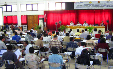
There
were over 170 participants at the conference and seventeen
presentations were delivered over the two days. A wide
range of spatial data applications from satellite based forest
monitoring to GIS for public health apllications where discussed
by leading experts from Europe the
United States and Indonesia as well as local practitioners
from Nusa Tenggara Timor and Timor Leste.
The
proceedings from the conference
will be published as a book by CDU press later in the year.
|